
Make a donation
Gliwice topographic map
Click on the map to display elevation.
Make a donation
About this map
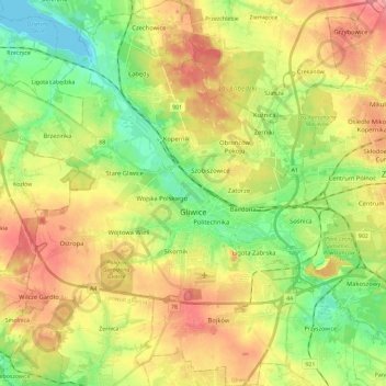
Name: Gliwice topographic map, elevation, terrain.
Location: Gliwice, Metropolis GZM, Silesian Voivodeship, Poland (50.22721 18.54299 50.37514 18.75632)
Average elevation: 240 m
Minimum elevation: 198 m
Maximum elevation: 289 m
Make a donation
Other topographic maps
Click on a map to view its topography, its elevation and its terrain.
Make a donation
Zwardoń
Poland > Silesian Voivodeship > Żywiec County
Zwardoń, located at the elevation of 690 meters above sea level, is placed between three mountain passes - Przysłop, Zwardońska and Graniczne. Until 1975, the village was administratively tied with Kraków and Lesser Poland. In 1975 - 1999, it belonged to Bielsko-Biala Voivodeship, and after the territorial…
Average elevation: 710 m
Młyńsko
Poland > Silesian Voivodeship > Żywiec County > Międzybrodzie Bialskie
Average elevation: 454 m
Make a donation
Make a donation
Make a donation
Strzyżowice - Biska
Poland > Silesian Voivodeship > Będzin County > Brzękowice-Wał
Average elevation: 333 m
Make a donation
Make a donation
Make a donation
Wilamowice
Poland > Silesian Voivodeship > Bielsko County > Wilamowice > Wilamowice
Average elevation: 273 m
Make a donation
Make a donation