
Thank you for supporting this site ❤️
Make a donation
Make a donation
Nußhardt topographic map
Click on the map to display elevation.
Thank you for supporting this site ❤️
Make a donation
Make a donation
Nußhardt
Der Nußhardt liegt am FGV-Hauptwanderweg Höhenweg zwischen dem FGV-Unterkunftshaus Seehaus und dem Schneeberg. Die Besteigungsanlage wird von der FGV-Ortsgruppe Vordorf betreut.
Thank you for supporting this site ❤️
Make a donation
Make a donation
About this map
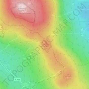
Name: Nußhardt topographic map, elevation, terrain.
Average elevation: 856 m
Minimum elevation: 691 m
Maximum elevation: 1,046 m
Thank you for supporting this site ❤️
Make a donation
Make a donation