
Thank you for supporting this site ❤️
Make a donation
Make a donation
Vinberg topographic map
Click on the map to display elevation.
Thank you for supporting this site ❤️
Make a donation
Make a donation
About this map
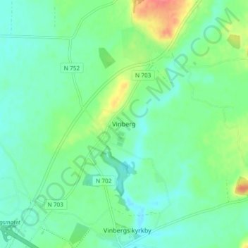
Name: Vinberg topographic map, elevation, terrain.
Location: Vinberg, Falkenbergs kommun, Halland County, 311 94, Sweden (56.92949 12.52805 56.96949 12.56805)
Average elevation: 29 m
Minimum elevation: 13 m
Maximum elevation: 69 m
Thank you for supporting this site ❤️
Make a donation
Make a donation
Other topographic maps
Click on a map to view its topography, its elevation and its terrain.
Thank you for supporting this site ❤️
Make a donation
Make a donation
Thank you for supporting this site ❤️
Make a donation
Make a donation