
Thank you for supporting this site ❤️
Make a donation
Make a donation
Santo Tirso topographic map
Click on the map to display elevation.
Thank you for supporting this site ❤️
Make a donation
Make a donation
Santo Tirso
The highest point in the municipality is in the Alto de S. Jorge, in the parish of Refojos, with 527 meters of altitude. The municipality's current perimeter is 69 kilometres (43 miles).
Thank you for supporting this site ❤️
Make a donation
Make a donation
About this map
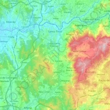
Name: Santo Tirso topographic map, elevation, terrain.
Location: Santo Tirso, Porto, Portugal (41.23807 -8.51985 41.38429 -8.31645)
Average elevation: 185 m
Minimum elevation: 23 m
Maximum elevation: 566 m
Thank you for supporting this site ❤️
Make a donation
Make a donation
Other topographic maps
Click on a map to view its topography, its elevation and its terrain.