
Make a donation
El Alto topographic map
Click on the map to display elevation.
Make a donation
About this map
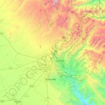
Name: El Alto topographic map, elevation, terrain.
Location: El Alto, Pedro Domingo Murillo, La Paz, Bolivia (-16.66698 -68.32013 -16.26266 -68.10827)
Average elevation: 4,144 m
Minimum elevation: 2,869 m
Maximum elevation: 6,059 m
Make a donation
Other topographic maps
Click on a map to view its topography, its elevation and its terrain.
La Paz
Bolivia > La Paz > Pedro Domingo Murillo > La Paz
The city, in west-central Bolivia 68 km (42 mi) southeast of Lake Titicaca, is set in a canyon created by the Choqueyapu River. It is in a bowl-like depression, part of the Amazon basin, surrounded by the high mountains of the Altiplano. Overlooking the city is the towering, triple-peaked Illimani. Its peaks…
Average elevation: 4,087 m
Illimani
Bolivia > La Paz > Pedro Domingo Murillo > Palca
Illimani (Aymara and Spanish pronunciation: [iʎiˈmani]) is a prominent fold mountain within the Cordillera Real of Bolivia, a subrange of the greater Andes, and located approximately 82 kilometres (51 mi) southeast of La Paz. With an elevation of 6,438 metres (21,120 ft) at its summit, it is the highest…
Average elevation: 5,756 m
Make a donation
Make a donation