
Thank you for supporting this site ❤️
Make a donation
Make a donation
Catalonia topographic map
Click on the map to display elevation.
Thank you for supporting this site ❤️
Make a donation
Make a donation
Catalonia
In the Mediterranean area, summers are dry and hot with sea breezes, and the maximum temperature is around 26–31 °C (79–88 °F). Winter is cool or slightly cold depending on the location. It snows frequently in the Pyrenees, and it occasionally snows at lower altitudes, even by the coastline. Spring and autumn are typically the rainiest seasons, except for the Pyrenean valleys, where summer is typically stormy.
Thank you for supporting this site ❤️
Make a donation
Make a donation
About this map
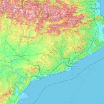
Name: Catalonia topographic map, elevation, terrain.
Location: Catalonia, Spain (40.52298 0.15941 42.86152 3.32225)
Average elevation: 559 m
Minimum elevation: -5 m
Maximum elevation: 3,311 m
Thank you for supporting this site ❤️
Make a donation
Make a donation
Other topographic maps
Click on a map to view its topography, its elevation and its terrain.
Thank you for supporting this site ❤️
Make a donation
Make a donation
Thank you for supporting this site ❤️
Make a donation
Make a donation
Thank you for supporting this site ❤️
Make a donation
Make a donation
Thank you for supporting this site ❤️
Make a donation
Make a donation