
Make a donation
Vienna topographic map
Click on the map to display elevation.
Make a donation
Vienna
Vienna is located in northeastern Austria, at the easternmost extension of the Alps in the Vienna Basin. The earliest settlement, at the location of today's inner city, was south of the meandering Danube while the city now spans both sides of the river. Elevation ranges from 151 to 542 m (495 to 1,778 ft). The city has a total area of 414.65 square kilometers (160.1 sq mi), making it the largest city in Austria by area.
Make a donation
About this map
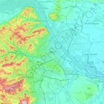
Name: Vienna topographic map, elevation, terrain.
Location: Vienna, 1010, Austria (48.04835 16.21250 48.36835 16.53250)
Average elevation: 231 m
Minimum elevation: 145 m
Maximum elevation: 650 m
Make a donation
Other topographic maps
Click on a map to view its topography, its elevation and its terrain.
Vienna
Vienna is located in northeastern Austria, at the easternmost extension of the Alps in the Vienna Basin. The earliest settlement, at the location of today's inner city, was south of the meandering Danube while the city now spans both sides of the river. Elevation ranges from 151 to 542 m (495 to 1,778 ft). The…
Average elevation: 227 m
Make a donation
Schneeberg
Austria > Lower Austria > Bezirk Neunkirchen > Schwarzau im Gebirge
A rack-and-pinion railway, the Schneeberg Railway, now over 100 years old, climbs to a height of 1,800 m (5,900 ft), reducing the walk to the summit to an hour or two. There are also a number of other routes for walkers, including from the spa resort of Puchberg am Schneeberg to the east, or from the south, in…
Average elevation: 1,081 m
Make a donation
Make a donation
Nauders
Austria > Tyrol > Bezirk Landeck
The town lies in the valley of the Stillebach (a tributary of the Inn) in the Ötztal Alps, at an altitude of 1,394 m (4,573 ft). It is located about 29 km (18 mi) south of the district capital Landeck, on the road that leads from Pfunds in the Inntal valley via the narrow Finstermünz Gorge up to Reschen Pass…
Average elevation: 1,938 m
Vienna
Vienna is located in northeastern Austria, at the easternmost extension of the Alps in the Vienna Basin. The earliest settlement, at the location of today's inner city, was south of the meandering Danube, while the city now spans both sides of the river. Elevation ranges from 151 to 542 m (495 to 1,778 ft).…
Average elevation: 227 m
Make a donation
Make a donation
Hall in Tirol
Austria > Tyrol > Bezirk Innsbruck-Land
Hall in Tirol is a town in the Innsbruck-Land district of Tyrol, Austria. Located at an altitude of 574 m, about 5 km (3 mi) east of the state's capital Innsbruck in the Inn valley, it has a population of 14,771 (Dec 2023).
Average elevation: 648 m
Make a donation
Make a donation
Make a donation
Vienna
Vienna is located in northeastern Austria, at the easternmost extension of the Alps in the Vienna Basin. The earliest settlement, at the location of today's inner city, was south of the meandering Danube, while the city now spans both sides of the river. Elevation ranges from 151 to 542 m (495 to 1,778 ft).…
Average elevation: 227 m
Altenberg bei Linz
Austria > Upper Austria > Bezirk Urfahr-Umgebung
Located on a southern part of the Zentralmühlviertler Hochland [de] at an altitude of 592 meters, the municipality has a view over the Mühlviertel region, Linz, the capital of Upper Austria as well as the so-called Zentralland and even the foothills of the Northern Limestone Alps. Because of that, it has…
Average elevation: 573 m
Make a donation
Nationalpark Kalkalpen
Austria > Upper Austria > Bezirk Kirchdorf
Kalkalpen National Park has visitors centers in Molln, Ennstal, and at the Hengstpaßhütt near Rosenau. The Wurbauerkogel, a 21 metres (69 ft) high panorama view tower, is located near Windischgarsten. It is accessible by a chair lift and hiking paths. In clear weather 21 peaks of 2,000 metres (6,600 ft) or…
Average elevation: 952 m
High Tauern National Park
The best-known mountain pass road of the High Tauern is the scenic Grossglockner High Alpine Road inaugurated in 1935, including a tunnel at an elevation of 2,505 metres (8,219 ft) under the Hochtor Pass (2,573 metres (8,442 ft)). East of it, the Katschberg Pass (1,641 metres (5,384 ft)) on B 99 Katschberg…
Average elevation: 1,710 m
Bad Gastein
Bad Gastein has a humid continental climate (Dfb) bordering on a subarctic climate (Dfc) due to the town's high elevation. Summers are mild, sometimes warm with cool, refreshing nights. Winters are moderately cold and snowy, with annual snowfall averaging 345 cm (136 inches).
Average elevation: 1,929 m
Make a donation
Wachau Cultural Landscape
Austria > Lower Austria > Bezirk Krems
The Danube valley in Austria between the cities of Melk and Krems in Lower Austria is called the Wachau. This stretch of the valley includes the hills and the adjacent Dunkelsteiner Wald (Dunkelsteiner Forest) and the southern Waldviertel. The Danube river flows north-northeast from Melk to Dürnstein through…
Average elevation: 486 m
Make a donation
Make a donation
Kaprun
Austria > Salzburg > Bezirk Zell am See
Kaprun (German pronunciation: [kaˈpruːn]) is a municipality in the Zell am See District in the province of Salzburg in Austria. Together with the neighboring city of Zell am See the town presents itself as the tourist destination and skiing area "Zell am See-Kaprun". Kaprun distinguishes itself from its…
Average elevation: 1,819 m
Make a donation
Schärding
Austria > Upper Austria > Bezirk Schärding
The town sits at an altitude of 313 meters and is located in the Innviertel. It measures 4.1 kilometers from north to south, 1.9 km from west to east. The total area is 4.08 km². 2.4 percent of the area is forested, 31.7 percent is used for agriculture.
Average elevation: 323 m
Make a donation
Hall in Tirol
Austria > Tyrol > Bezirk Innsbruck-Land
Hall in Tirol is a town in the Innsbruck-Land district of Tyrol, Austria. Located at an altitude of 574 m, about 5 km (3 mi) east of the state's capital Innsbruck in the Inn valley, it has a population of 14,771 (Dec 2023).
Average elevation: 648 m
Make a donation
Make a donation
Make a donation
Make a donation
2641
Austria > Lower Austria > Bezirk Neunkirchen > Schottwien > Maria Schutz
Average elevation: 905 m
Make a donation
Steyr
The city is situated in the Traunviertel region, with the two rivers Steyr and Enns flowing through it and meeting near the town centre beneath Lamberg Castle and St Michael's Church. This prominent location has made it prone to severe flooding through the centuries until the present, one of the worst cases…
Average elevation: 341 m
Make a donation
Perchtoldsdorfer Heide
Austria > Lower Austria > Bezirk Mödling > Perchtoldsdorf
Average elevation: 312 m
Make a donation
Hallstatt
Austria > Upper Austria > Bezirk Gmunden
The Hallstatt salt mine is the world's oldest working salt mine. The mine is located within the Upper Permian to Lower Triassic Haselgebirge Formation of the Northern Limestone Alps. The Hallstatt salt mine comprises 21 levels and several smaller shafts ranging from 514 m above sea level (Erbstollen level) to…
Average elevation: 1,514 m
Make a donation
Hinterstoder
Austria > Upper Austria > Bezirk Kirchdorf
Hinterstoder is a municipality in the district of Kirchdorf an der Krems, in the Austrian state of Upper Austria. The village lies on the southern edge of the district near the border with Styria, at an altitude of around 600 m. Surrounded by the limestone peaks of the Totes Gebirge range, including the…
Average elevation: 1,283 m
Make a donation
Make a donation
Lechquellengebirge
Austria > Vorarlberg > Bezirk Bludenz
The use of high-altitude roads (tolls) allows the motor vehicle to penetrate the interior of the mountains to a height of almost 2000 meters. But there are also larger areas with marked seclusion.
Average elevation: 1,568 m
Make a donation