
Make a donation
Mont-Dore topographic map
Click on the map to display elevation.
Make a donation
Mont-Dore
The thermal springs of Mont-Dore, now numbering twelve, were known to the Romans. Sodium bicarbonate, iron and arsenic are the principal ingredients of the waters, which are used both for drinking and bathing. Hot baths are characteristic of the treatment; they are believed to be efficacious for tuberculosis, bronchitis, asthma, and nervous and rheumatic paralysis. Due to the elevation and exposure of the valley, the climate of Mont-Dore is relatively severe, and the season only lasts from 15 June to 15 September. The bath-house was rebuilt in 1891–1894.
Make a donation
About this map
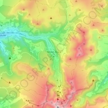
Name: Mont-Dore topographic map, elevation, terrain.
Average elevation: 1,300 m
Minimum elevation: 860 m
Maximum elevation: 1,872 m
Make a donation
Other topographic maps
Click on a map to view its topography, its elevation and its terrain.
La Graissière
France > Auvergne-Rhône-Alpes > Puy-de-Dôme > Saint-Genès-Champanelle
Average elevation: 984 m
Make a donation
Beaune-le-Chaud
France > Auvergne-Rhône-Alpes > Puy-de-Dôme > Saint-Genès-Champanelle
Average elevation: 941 m
Make a donation
Les Gicons
France > Auvergne-Rhône-Alpes > Puy-de-Dôme > Montaigut-en-Combraille
Average elevation: 608 m
La Live
France > Auvergne-Rhône-Alpes > Puy-de-Dôme > Glaine-Montaigut > Glaine
Average elevation: 363 m
Make a donation
Soulace
France > Auvergne-Rhône-Alpes > Puy-de-Dôme > Marsac-en-Livradois > Flaittes
Average elevation: 621 m
Make a donation
Make a donation
La Cottas
France > Auvergne-Rhône-Alpes > Puy-de-Dôme > Champétières > Chatelet
Average elevation: 779 m
Andan
France > Auvergne-Rhône-Alpes > Puy-de-Dôme > Saint-Jacques-d'Ambur > Andan
Average elevation: 624 m
Les Chaux
France > Auvergne-Rhône-Alpes > Puy-de-Dôme > Saint-Amant-Roche-Savine > Les Chaux
Average elevation: 901 m
Mareuge
France > Auvergne-Rhône-Alpes > Puy-de-Dôme > Le Vernet-Sainte-Marguerite
Average elevation: 1,062 m
Make a donation