
Thank you for supporting this site ❤️
Make a donation
Make a donation
Capanema topographic map
Click on the map to display elevation.
Thank you for supporting this site ❤️
Make a donation
Make a donation
Capanema
'Capanema' is a municipality in the state of Pará. It is located at a latitude 01 ° 11'45 "South and longitude 47 ° 10'51" west, with an altitude of 24 meters. Its population in 2020 was 69,431 inhabitants. Despite being a city average, requires great influence in the region in trade and services. A receptive and lively city, where it became home to many immigrants from various regions of Brazil, mainly from Northeast.
Thank you for supporting this site ❤️
Make a donation
Make a donation
About this map
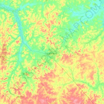
Name: Capanema topographic map, elevation, terrain.
Average elevation: 32 m
Minimum elevation: 0 m
Maximum elevation: 77 m
Thank you for supporting this site ❤️
Make a donation
Make a donation
Other topographic maps
Click on a map to view its topography, its elevation and its terrain.