
Thank you for supporting this site ❤️
Make a donation
Make a donation
Nisa topographic map
Click on the map to display elevation.
Thank you for supporting this site ❤️
Make a donation
Make a donation
About this map
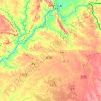
Name: Nisa topographic map, elevation, terrain.
Location: Nisa, Portalegre, Portugal (39.37724 -7.88292 39.66368 -7.48047)
Average elevation: 258 m
Minimum elevation: 47 m
Maximum elevation: 483 m
Thank you for supporting this site ❤️
Make a donation
Make a donation
Other topographic maps
Click on a map to view its topography, its elevation and its terrain.