
Thank you for supporting this site ❤️
Make a donation
Make a donation
Mürringen topographic map
Click on the map to display elevation.
Thank you for supporting this site ❤️
Make a donation
Make a donation
About this map
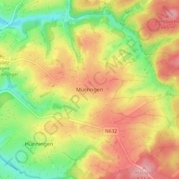
Name: Mürringen topographic map, elevation, terrain.
Location: Mürringen, Büllingen, Verviers, Lieja, Valonia, 4760, Bélgica (50.38678 6.28925 50.42678 6.32925)
Average elevation: 624 m
Minimum elevation: 563 m
Maximum elevation: 677 m
Thank you for supporting this site ❤️
Make a donation
Make a donation
Other topographic maps
Click on a map to view its topography, its elevation and its terrain.