
Thank you for supporting this site ❤️
Make a donation
Make a donation
Cape Horn topographic map
Click on the map to display elevation.
Thank you for supporting this site ❤️
Make a donation
Make a donation
About this map
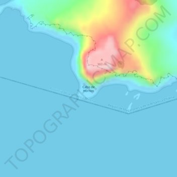
Name: Cape Horn topographic map, elevation, terrain.
Average elevation: 49 m
Minimum elevation: -1 m
Maximum elevation: 324 m
Thank you for supporting this site ❤️
Make a donation
Make a donation
Other topographic maps
Click on a map to view its topography, its elevation and its terrain.
Chair
Chile > Region of Magallanes and Chilean Antarctica > Provincia de la Antártica Chilena > Cape Horn
Average elevation: 18 m
Isla Milne Edwards
Chile > Region of Magallanes and Chilean Antarctica > Provincia de la Antártica Chilena > Cape Horn
Average elevation: 149 m