
Make a donation
Jičín topographic map
Click on the map to display elevation.
Make a donation
Jičín
Jičín is located about 85 km (53 mi) northeast of Prague. It lies in the heart of the Jičín Uplands. The highest point is the hill Zebín with an altitude of 399 m (1,309 ft). The town is situated on the Cidlina river. Several other small watercources also flow through the municipal territory, including streams Valdický, Popovický, Úlibický, and Trnávka. There are five ponds in the territory, the largest of them is Šibeňák. Ponds Kníže and Šibeňák are located right in the urban area.
Make a donation
About this map
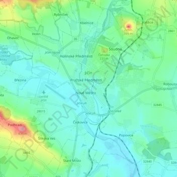
Name: Jičín topographic map, elevation, terrain.
Average elevation: 289 m
Minimum elevation: 256 m
Maximum elevation: 408 m
Make a donation
Other topographic maps
Click on a map to view its topography, its elevation and its terrain.
Velká Deštná
Czechia > Northeast > Královéhradecký kraj > Deštné v Orlických horách
Velká Deštná (German: Deschneyer Großkoppe) is a mountain in the Hradec Králové Region of the Czech Republic. With an elevation of 1,116 m (3,661 ft), it is the highest mountain of the Orlické Mountains and of the whole Central Sudetes range. There is an observation tower on top of the mountain, which…
Average elevation: 962 m
Make a donation
Make a donation