
Thank you for supporting this site ❤️
Make a donation
Make a donation
Léglise topographic map
Click on the map to display elevation.
Thank you for supporting this site ❤️
Make a donation
Make a donation
About this map
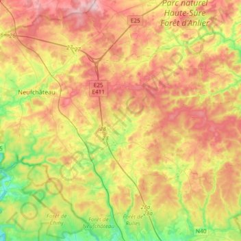
Name: Léglise topographic map, elevation, terrain.
Location: Léglise, Neufchâteau, Luxembourg, Wallonia, 6860, Belgium (49.73433 5.41165 49.90092 5.70534)
Average elevation: 441 m
Minimum elevation: 328 m
Maximum elevation: 558 m
Thank you for supporting this site ❤️
Make a donation
Make a donation
Other topographic maps
Click on a map to view its topography, its elevation and its terrain.
Thank you for supporting this site ❤️
Make a donation
Make a donation
Thank you for supporting this site ❤️
Make a donation
Make a donation