
Thank you for supporting this site ❤️
Make a donation
Make a donation
Montero topographic map
Click on the map to display elevation.
Thank you for supporting this site ❤️
Make a donation
Make a donation
Montero
Montero has an elevation of about 300 meters above sea level and an average temperature of 23 °C (73.4 °F). The city is predominantly agricultural, producing soybeans, cotton, corn, and rice.
Thank you for supporting this site ❤️
Make a donation
Make a donation
About this map
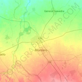
Name: Montero topographic map, elevation, terrain.
Location: Montero, Provincia Obispo Santistevan, Santa Cruz, Bolivia (-17.41899 -63.34717 -17.21069 -63.09104)
Average elevation: 285 m
Minimum elevation: 254 m
Maximum elevation: 319 m
Thank you for supporting this site ❤️
Make a donation
Make a donation
Other topographic maps
Click on a map to view its topography, its elevation and its terrain.
General Saavedra
Bolivia > Santa Cruz > Provincia Obispo Santistevan > Municipio General Saavedra > General Saavedra
Average elevation: 269 m