
Make a donation
Darmstadt topographic map
Click on the map to display elevation.
Make a donation
About this map
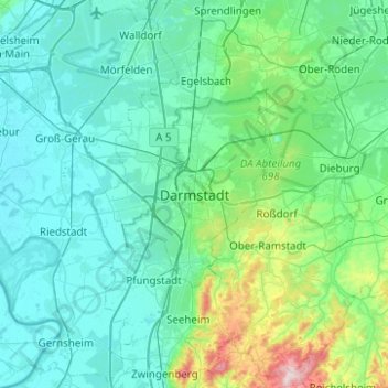
Name: Darmstadt topographic map, elevation, terrain.
Location: Darmstadt, Hesse, 64283, Germany (49.71278 8.49118 50.03278 8.81118)
Average elevation: 151 m
Minimum elevation: 82 m
Maximum elevation: 604 m
Make a donation
Other topographic maps
Click on a map to view its topography, its elevation and its terrain.
Wiesbaden
The highest point of the Wiesbaden municipality is located northwest of the city center near the summit of the Hohe Wurzel, with an elevation of 608 metres (1,995 ft) above sea level. The lowest point is the harbour entrance of Schierstein at 83 metres (272 ft) above sea level. The central square (the…
Average elevation: 221 m
Bad Hersfeld
Germany > Hesse > Landkreis Hersfeld-Rotenburg
The Flugplatz Johannesberg has the status of Special Airfield. The runway, some 671 m long and 18 m wide, is paved with asphalt and oriented in a north–south direction. The airfield lies on the Johannesberg in the like-named outlying centre at an elevation of 284 m above sea level.
Average elevation: 305 m
Make a donation
Wiesbaden
The highest point of the Wiesbaden municipality is located northwest of the city center near the summit of the Hohe Wurzel, with an elevation of 608 metres (1,995 ft) above sea level. The lowest point is the harbour entrance of Schierstein at 83 metres (272 ft) above sea level. The central square (the…
Average elevation: 221 m
Make a donation
Zwingenberg
Germany > Hesse > Kreis Bergstraße
Zwingenberg lies on the western edge of the Odenwald at the foot of the Melibokus, at 517.4 m above sea level the Bergstraße's highest mountain. The municipal area's elevation varies between roughly 90 m above sea level in the outlying centre of Rodau and just under 300 m on the slope of the Melibokus.…
Average elevation: 104 m
Make a donation
Make a donation
Igstadt
Igstadt is situated on the eastern slope of the Wäschbachtal valley at an elevation of 169 to 211 m above sea level. It is traversed by the Wiesbaden-Niedernhausen rail line. It is surrounded by agricultural land. Recreational areas include the Wickerbachtal Nature Reserve between Igstadt and Kloppenheim.
Average elevation: 198 m
Make a donation
Make a donation
Make a donation
Limburg an der Lahn
Germany > Hesse > Landkreis Limburg-Weilburg
The town lies roughly centrally in a basin within the Rhenish Slate Mountains which is surrounded by the low ranges of the Taunus and Westerwald and called the Limburg Basin (Limburger Becken). Owing to the favourable soil and climate, the Limburg Basin stands as one of Hesse's richest agricultural regions and…
Average elevation: 163 m
Freigericht
Germany > Hesse > Main-Kinzig-Kreis
Freigericht has an elevation of 140 to 371 m in a side valley of the Kinzig river.
Average elevation: 224 m
Make a donation
Make a donation
Make a donation
Make a donation
Make a donation
Make a donation
Make a donation
Make a donation
Make a donation
Make a donation
Dietkirchen
Germany > Hesse > Landkreis Limburg-Weilburg > Limburg an der Lahn
Average elevation: 144 m
Make a donation
Make a donation
Reichelsheim (Odenwald)
Germany > Hesse > Odenwaldkreis
Reichelsheim lies in the middle Odenwald at elevations between 200 and 538 m in the middle of the Geo-Naturpark Bergstraße-Odenwald.
Average elevation: 335 m
Make a donation
Make a donation
Make a donation
Make a donation
Make a donation
Make a donation