
Thank you for supporting this site ❤️
Make a donation
Make a donation
Tremês topographic map
Click on the map to display elevation.
Thank you for supporting this site ❤️
Make a donation
Make a donation
About this map
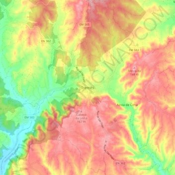
Name: Tremês topographic map, elevation, terrain.
Location: Tremês, Santarém, 2025-562, Portugal (39.31929 -8.80136 39.39929 -8.72136)
Average elevation: 104 m
Minimum elevation: 18 m
Maximum elevation: 169 m
Thank you for supporting this site ❤️
Make a donation
Make a donation
Other topographic maps
Click on a map to view its topography, its elevation and its terrain.