
Make a donation
Molina topographic map
Click on the map to display elevation.
Make a donation
About this map
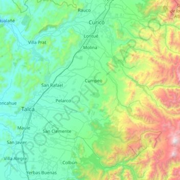
Name: Molina topographic map, elevation, terrain.
Location: Molina, Provincia de Curicó, Maule Region, Chile (-35.63041 -71.50302 -35.02723 -70.38652)
Average elevation: 669 m
Minimum elevation: 24 m
Maximum elevation: 3,940 m
Make a donation
Other topographic maps
Click on a map to view its topography, its elevation and its terrain.
Peteroa
Chile > Maule Region > Provincia de Curicó > Sagrada Familia > Santa Ana
Average elevation: 139 m
Zona Central
Chile > Maule Region > Provincia de Curicó > Teno
The topography of central Chile includes a coastal range of mountains running parallel to the Andes. Lying between the two mountain ranges is the so-called Central Valley, which contains some of the richest agricultural land in the country, especially in its northern portion. The area just north and south of…
Average elevation: 1,121 m