
Thank you for supporting this site ❤️
Make a donation
Make a donation
Nynäshamn topographic map
Click on the map to display elevation.
Thank you for supporting this site ❤️
Make a donation
Make a donation
About this map
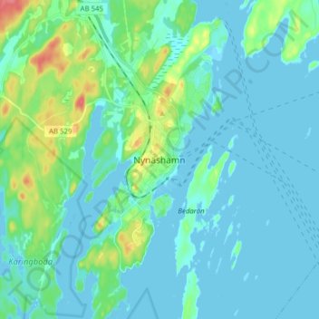
Name: Nynäshamn topographic map, elevation, terrain.
Location: Nynäshamn, Nynäshamns kommun, Stockholm County, 149 81, Sweden (58.86565 17.90710 58.94565 17.98710)
Average elevation: 11 m
Minimum elevation: -1 m
Maximum elevation: 65 m
Thank you for supporting this site ❤️
Make a donation
Make a donation
Other topographic maps
Click on a map to view its topography, its elevation and its terrain.