
Make a donation
Zürs topographic map
Click on the map to display elevation.
Make a donation
Zürs
Tourism is the main source of income for the town of Zürs. Due to its high altitude (over 2,000m), the landscape is largely free of forest and therefore offers a clear view of the surrounding Alpine peaks. In addition, there is always plenty of snow in the Arlberg region, providing a picturesque setting for winter sports.
Make a donation
About this map
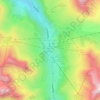
Name: Zürs topographic map, elevation, terrain.
Location: Zürs, Lech, Bezirk Bludenz, Vorarlberg, 6763, Austria (47.15122 10.14317 47.19122 10.18317)
Average elevation: 2,055 m
Minimum elevation: 1,551 m
Maximum elevation: 2,680 m
Make a donation
Other topographic maps
Click on a map to view its topography, its elevation and its terrain.
Make a donation
Lechquellengebirge
Austria > Vorarlberg > Bezirk Bludenz
The use of high-altitude roads (tolls) allows the motor vehicle to penetrate the interior of the mountains to a height of almost 2000 meters. But there are also larger areas with marked seclusion.
Average elevation: 1,568 m
Make a donation
Brandnertal
Austria > Vorarlberg > Bezirk Bludenz > Brand
The Brandnertal is located in the southern part of Vorarlberg, in the far west of Austria. Adjacent to Switzerland, the Principality of Liechtenstein and Germany. In the immediate vicinity of the city of Bludenz starts the Brandnertal. From Bürs the valley rises, via Bürserberg to Brand, which is at an…
Average elevation: 1,572 m
Make a donation
Marktgemeinde Schruns
Austria > Vorarlberg > Bezirk Bludenz
Schruns is a municipality in the Montafon valley (altitude 690 meters), in the Bludenz district of the westernmost Austrian state of Vorarlberg.
Average elevation: 1,375 m
Make a donation
Gemeinde Lech
Austria > Vorarlberg > Bezirk Bludenz
The altitude of 1444 m for the village refers to the location of the old church on a hill. 14.1% of the municipal area is forested, 58% of the area is Alpine. Geographically and historically, Lech belongs to the Hochtannberg region, formerly Tannberg, but in terms of tourism the municipality is part of the…
Average elevation: 1,947 m
Gemeinde Tschagguns
Austria > Vorarlberg > Bezirk Bludenz > Gemeinde Tschagguns
Average elevation: 1,626 m