
Thank you for supporting this site ❤️
Make a donation
Make a donation
Purísima topographic map
Click on the map to display elevation.
Thank you for supporting this site ❤️
Make a donation
Make a donation
About this map
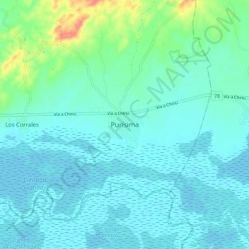
Name: Purísima topographic map, elevation, terrain.
Location: Purísima, Bajo Sínú, Córdoba, Colombia (9.19753 -75.76361 9.27753 -75.68361)
Average elevation: 13 m
Minimum elevation: -3 m
Maximum elevation: 81 m
Thank you for supporting this site ❤️
Make a donation
Make a donation
Other topographic maps
Click on a map to view its topography, its elevation and its terrain.
Resguardo Zenú de San Andrés de Sotavento
Colombia > Córdoba > Purísima > Tuchín
Average elevation: 69 m