
Make a donation
Masovian Voivodeship topographic map
Click on the map to display elevation.
Make a donation
About this map
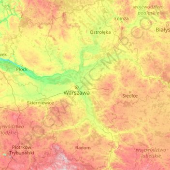
Name: Masovian Voivodeship topographic map, elevation, terrain.
Location: Masovian Voivodeship, Poland (51.01314 19.25921 53.48181 23.12841)
Average elevation: 146 m
Minimum elevation: 51 m
Maximum elevation: 400 m
Make a donation
Other topographic maps
Click on a map to view its topography, its elevation and its terrain.
Rysy
Poland > Lesser Poland Voivodeship > Tatra County > Brzegi
It is possible to reach the peak from the Slovak side, starting at Štrbské pleso and passing Chata pod Rysmi, a mountain chalet at an altitude of 2,250 m (7,380 ft). Between November 1 and June 15, the trail and chalet on the Slovak side are closed.
Average elevation: 2,005 m
Make a donation
Smogornia / Stříbrný hřbet
Poland > Lower Silesian Voivodeship > Karkonosze County > Borowice
Average elevation: 1,336 m
Make a donation
Grabiczek
Poland > Warmian-Masurian Voivodeship > Ostróda County > Wólka Lichtajńska
Average elevation: 118 m
Make a donation
Kable
Poland > Greater Poland Voivodeship > Czarnków-Trzcianka County > Klempicz
Average elevation: 73 m