
Thank you for supporting this site ❤️
Make a donation
Make a donation
San Carlo topographic map
Click on the map to display elevation.
Thank you for supporting this site ❤️
Make a donation
Make a donation
About this map
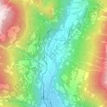
Name: San Carlo topographic map, elevation, terrain.
Location: San Carlo, Poschiavo, Bernina, Grisons, 7741, Switzerland (46.32089 10.03961 46.36089 10.07961)
Average elevation: 1,497 m
Minimum elevation: 1,005 m
Maximum elevation: 2,244 m
Thank you for supporting this site ❤️
Make a donation
Make a donation
Other topographic maps
Click on a map to view its topography, its elevation and its terrain.