
Thank you for supporting this site ❤️
Make a donation
Make a donation
Körbecke topographic map
Click on the map to display elevation.
Thank you for supporting this site ❤️
Make a donation
Make a donation
About this map
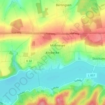
Name: Körbecke topographic map, elevation, terrain.
Average elevation: 249 m
Minimum elevation: 208 m
Maximum elevation: 306 m
Thank you for supporting this site ❤️
Make a donation
Make a donation
Other topographic maps
Click on a map to view its topography, its elevation and its terrain.
Thank you for supporting this site ❤️
Make a donation
Make a donation
Warstein
Germany > North Rhine-Westphalia > Kreis Soest
Warstein is located north of the Arnsberger Wald (forest), at a brook called Wäster. The area south of the city is mostly forested; the lightly forested Haarstrang mountain is to the north. The river Möhne flows between these two areas. The highest elevation is 581 m (1,906 ft) in the south of the city near…
Average elevation: 373 m
Thank you for supporting this site ❤️
Make a donation
Make a donation
Thank you for supporting this site ❤️
Make a donation
Make a donation