
Thank you for supporting this site ❤️
Make a donation
Make a donation
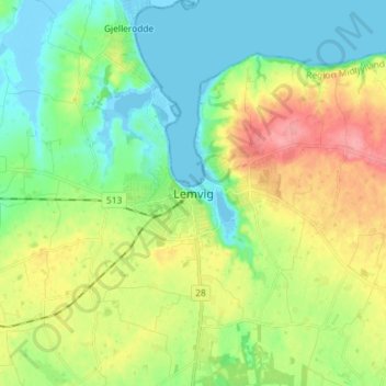
Lemvig topographic map
Click on the map to display elevation.
Thank you for supporting this site ❤️
Make a donation
Make a donation
Lemvig
Lemvig is a 750-year-old market town, and received its municipal charter in 1545. One of the landmarks of Lemvig is the town church from the 13th century. The old town is situated between the Limfjord, a lake and some hills. The local topography was shaped during the last Ice Age.
Thank you for supporting this site ❤️
Make a donation
Make a donation
About this map
Name: Lemvig topographic map, elevation, terrain.
Average elevation: 31 m
Minimum elevation: -4 m
Maximum elevation: 84 m
Thank you for supporting this site ❤️
Make a donation
Make a donation