
Thank you for supporting this site ❤️
Make a donation
Make a donation
Tân Uyên topographic map
Click on the map to display elevation.
Thank you for supporting this site ❤️
Make a donation
Make a donation
About this map
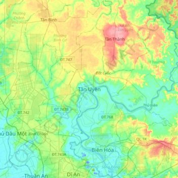
Name: Tân Uyên topographic map, elevation, terrain.
Location: Tân Uyên, Ho Chi Minh City, Bình Dương Province, Vietnam (10.90006 106.63752 11.22006 106.95752)
Average elevation: 31 m
Minimum elevation: -21 m
Maximum elevation: 99 m
Thank you for supporting this site ❤️
Make a donation
Make a donation
Other topographic maps
Click on a map to view its topography, its elevation and its terrain.
Thank you for supporting this site ❤️
Make a donation
Make a donation
Bến Cát
Ben Cat is in the transition zone from the Trường Sơn range in the north of the central highland to the southern plain, so the general topography of the whole town is relatively high from 30 to 35m above sea level in the north and lower to the south. In the south, the climate belongs to the tropical…
Average elevation: 25 m
Thank you for supporting this site ❤️
Make a donation
Make a donation
Thank you for supporting this site ❤️
Make a donation
Make a donation
Thank you for supporting this site ❤️
Make a donation
Make a donation
Thank you for supporting this site ❤️
Make a donation
Make a donation