
Thank you for supporting this site ❤️
Make a donation
Make a donation
Haukeli topographic map
Click on the map to display elevation.
Thank you for supporting this site ❤️
Make a donation
Make a donation
About this map
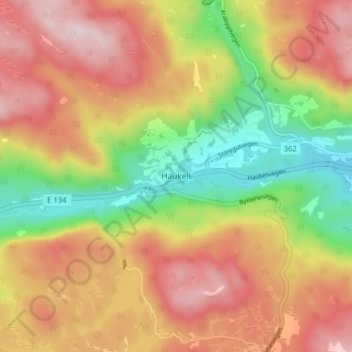
Name: Haukeli topographic map, elevation, terrain.
Location: Haukeli, Vinje, Vestfold og Telemark, Norway (59.71596 7.53782 59.75596 7.57782)
Average elevation: 798 m
Minimum elevation: 541 m
Maximum elevation: 1,034 m
Thank you for supporting this site ❤️
Make a donation
Make a donation
Other topographic maps
Click on a map to view its topography, its elevation and its terrain.