
Make a donation
Wallis topographic map
Click on the map to display elevation.
Make a donation
Wallis
Valais is the highest canton in terms of absolute, relative, and mean elevation. Therefore, its topography is extremely rugged, with the notable exception of the wide, glacial, Rhône valley. The latter valley dominates the geography of the canton. Many side valleys are branching off the main valley, often perpendicularly. These vary from narrow and remote to reasonably populous. On the south side of the Rhône, in the Valais Alps, some of the largest side valleys are (from east to west): the Mattertal (including the Saastal), the Val d'Anniviers, the Val d'Hérens, the Val de Bagnes and the Val d'Entremont. On the north of the Rhône, in the Bernese Alps, the Lötschental is the only large valley. East of Brig is the valley of Goms, the highest section of the Rhône Valley. The Rhône itself flows in the main valley from east to west from the Rhône Glacier down to Martigny, then at a right angle north to its mouth in Lake Geneva. After the town of Saint-Maurice, the eastern banks of the river belong to the canton of Vaud, although the western banks remain in Valais, down to Le Bouveret, on the shores of Lake Geneva. The main valley is bounded by the Bernese Alps in the north and the Valais Alps in the south, both ranges including numerous over 4,000 metre-high mountains, which are the highest in the country. Notables mountains include Monte Rosa (highest), reaching 4,634 metres (15,203 ft), and the Finsteraarhorn (most prominent), reaching 4,274 metres (14,022 ft). Other iconic mountains are the Matterhorn and the Jungfrau, for a complete list, see list of mountains of Valais. Located there are numerous glaciers including several of the largest in the Alps, such as the Aletsch Glacier and the Gorner Glacier. Other ranges situated partially in Valais are the Chablais Alps, the Mont Blanc Massif, the Uri Alps, the Gotthard Massif, and the Lepontine Alps.
Make a donation
About this map
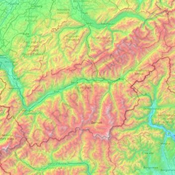
Name: Wallis topographic map, elevation, terrain.
Location: Wallis, Switzerland (45.85831 6.77063 46.65405 8.47856)
Average elevation: 1,728 m
Minimum elevation: 190 m
Maximum elevation: 4,728 m
Make a donation
Other topographic maps
Click on a map to view its topography, its elevation and its terrain.
Monte Rosa
Switzerland > Wallis > Visp > Zermatt
The peak is distinguished by the name Dufourspitze (in German, lit. Dufour Peak; French: Pointe Dufour, Italian: Punta Dufour). This replaced the former name Höchste Spitze (English: Highest Peak) that was indicated on the Swiss maps before the Federal Council, on January 28, 1863, decided to rename the…
Average elevation: 4,033 m
Ramosch
Switzerland > Grisons > Region Engiadina Bassa/Val Müstair > Valsot
Average elevation: 1,501 m
Make a donation
Schloss Wittigkofen
Switzerland > Bern > Bern-Mittelland administrative district > Bern > Schloss Wittigkofen
Average elevation: 568 m
Kiental
Switzerland > Bern > Frutigen-Niedersimmental administrative district > Reichenbach im Kandertal
Average elevation: 1,363 m
Make a donation
Strandweg
Switzerland > St. Gallen > Wahlkreis See-Gaster > Rapperswil-Jona > Rapperswil
Average elevation: 408 m
Make a donation
Make a donation
Bern
Switzerland > Bern > Bern-Mittelland administrative district > Bern
Bern is built on very uneven ground. An elevation difference of up to 60 metres exists between the inner city districts on the Aare (Matte, Marzili) and the higher ones (Kirchenfeld, Länggasse).
Average elevation: 643 m
Make a donation
Make a donation