
Make a donation
Aubinyà topographic map
Click on the map to display elevation.
Make a donation
About this map
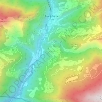
Name: Aubinyà topographic map, elevation, terrain.
Location: Aubinyà, Sant Julia de Loria, AD600, Andorra (42.43368 1.47214 42.47368 1.51214)
Average elevation: 1,303 m
Minimum elevation: 843 m
Maximum elevation: 2,045 m
Make a donation
Other topographic maps
Click on a map to view its topography, its elevation and its terrain.
Canillo
During the summer, mountain activities such as railroads, hiking and climbing routes are organized in the parish, as well as bike and cycling routes in Grand Valira and Vall d'Incles. In Canillo is located the highest golf course in Europe, located at 2,250 m altitude (7382 feet), created by the British…
Average elevation: 2,215 m
Sant Julia de Loria
Sant Julià de Lòria is one of the eight parishes of Andorra. Located in the south of the country, it is spread around the town of the same name. The town of Sant Julià de Lòria is the seat of the parish, and is headed by a mayor. It is situated in the Eastern Pyrenees region on the banks of the Gran Valira…
Average elevation: 1,647 m
Andorra la Vella
The principal industry is tourism, although the country also earns foreign income from being a tax haven. Furniture and brandies are local products. Being at an elevation of 1,023 m (3,356 ft), it is the highest capital city in Europe and a popular ski resort.
Average elevation: 1,270 m
Make a donation
Andorra la Vella
The principal industry is tourism, and the country also earns foreign income from being a tax haven. It is at an elevation of 1,023 m (3,356 ft), and is the highest capital city in Europe. The city shares a border with Spain.
Average elevation: 1,584 m
La Massana
Coma Pedrosa in the north-west of the parish is the highest point in the Principality of Andorra at 2,942 metres (9,652 ft), and has panoramic views of the Pyrenees. The mountain is also the site of the Coma Pedrosa Nature Reserve. It is covered by heavy snowfalls in winter, and usually retains some snow cover…
Average elevation: 1,877 m
Andorra la Vella
The principal industry is tourism, and the country also earns foreign income from being a tax haven. It is at an elevation of 1,023 m (3,356 ft), and is the highest capital city in Europe. The city shares a border with Spain.
Average elevation: 1,584 m
Make a donation
Encamp
Radio Andorra operated a transmitter at Lake Engolasters in Encamp from 7 August 1939 until 9 April 1981. The antenna still exists at an elevation of 1,600 metres (5,200 ft) (coordinates: 42°31′18″N 1°34′10″E / 42.52167°N 1.56944°E / 42.52167; 1.56944 (Radio Andorra transmitter)).
Average elevation: 1,992 m
La Massana
Coma Pedrosa in the north-west of the parish is the highest point in the Principality of Andorra at 2,942 metres (9,652 ft), and has panoramic views of the Pyrenees. The mountain is also the site of the Coma Pedrosa Nature Reserve. It is covered by heavy snowfalls in winter, and usually retains some snow cover…
Average elevation: 1,877 m