
Thank you for supporting this site ❤️
Make a donation
Make a donation
Pike's Peak topographic map
Click on the map to display elevation.
Thank you for supporting this site ❤️
Make a donation
Make a donation
About this map
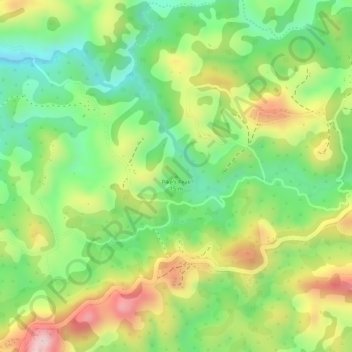
Name: Pike's Peak topographic map, elevation, terrain.
Average elevation: 1,707 m
Minimum elevation: 1,581 m
Maximum elevation: 1,859 m
Thank you for supporting this site ❤️
Make a donation
Make a donation
Other topographic maps
Click on a map to view its topography, its elevation and its terrain.
Lake Edward
Democratic Republic of the Congo > North Kivu > Lubero
Lake Edward lies at an elevation of 920 metres (3,020 ft), is 77 kilometres (48 mi) long by 40 kilometres (25 mi) wide at its maximum points, and covers a total surface area of 2,325 square kilometres (898 sq mi), making it the 15th-largest on the continent. The lake is fed by the Nyamugasani River, the…
Average elevation: 1,134 m