
Thank you for supporting this site ❤️
Make a donation
Make a donation
Edsåsdalen topographic map
Click on the map to display elevation.
Thank you for supporting this site ❤️
Make a donation
Make a donation
About this map
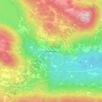
Name: Edsåsdalen topographic map, elevation, terrain.
Location: Edsåsdalen, Åre kommun, Provinz Jämtland, Schweden (63.29448 13.04807 63.33448 13.08807)
Average elevation: 590 m
Minimum elevation: 463 m
Maximum elevation: 750 m
Thank you for supporting this site ❤️
Make a donation
Make a donation
Other topographic maps
Click on a map to view its topography, its elevation and its terrain.
Thank you for supporting this site ❤️
Make a donation
Make a donation
Thank you for supporting this site ❤️
Make a donation
Make a donation