
Make a donation
Dorado topographic map
Click on the map to display elevation.
Make a donation
Dorado
Dorado is located in Puerto Rico's Northern Karst region. Much of its geology consists of alluvial and coastal/estuarine sediments of Quaternary age and limestones of Tertiary age. The limestones are mostly in the south part of the municipality, in Espinosa, Maguayo and Rio Lajas barrios. These limestones exhibit mature karst topography of great beauty. It has been subjected to extensive quarrying, which have left unsightly scars in the landscape. Some local communities have gathered efforts to minimize quarrying and improve land management to protect the remaining karst topography and the fauna and flora that lives in it. Around 95% of Dorado's terrain are flood plains while the rest is part of a limestone region. The terrains are naturally fertilized when the Dorado, Plata and Lajas rivers go out of their limits. The rock formation known as Ojo de Buey is tourist attraction, also being associated with legends of ghosts and the claim that the pirate captain Roberto Cofresí's treasure is buried near it.
Make a donation
About this map
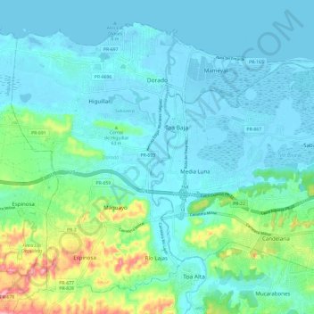
Name: Dorado topographic map, elevation, terrain.
Location: Dorado, Puerto Rico, United States (18.38305 -66.31730 18.48033 -66.19827)
Average elevation: 33 m
Minimum elevation: -3 m
Maximum elevation: 182 m
Make a donation
Other topographic maps
Click on a map to view its topography, its elevation and its terrain.