
Thank you for supporting this site ❤️
Make a donation
Make a donation
Finnerödja topographic map
Click on the map to display elevation.
Thank you for supporting this site ❤️
Make a donation
Make a donation
About this map
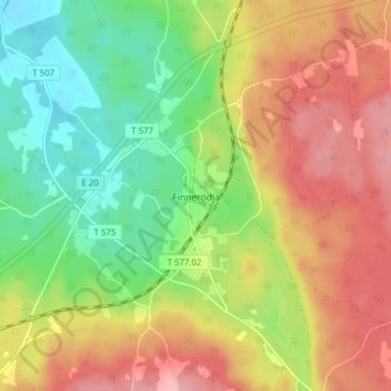
Name: Finnerödja topographic map, elevation, terrain.
Location: Finnerödja, Laxå kommun, Örebro County, Sweden (58.90854 14.42113 58.94854 14.46113)
Average elevation: 132 m
Minimum elevation: 76 m
Maximum elevation: 192 m
Thank you for supporting this site ❤️
Make a donation
Make a donation
Other topographic maps
Click on a map to view its topography, its elevation and its terrain.