
Thank you for supporting this site ❤️
Make a donation
Make a donation
Faro topographic map
Click on the map to display elevation.
Thank you for supporting this site ❤️
Make a donation
Make a donation
About this map
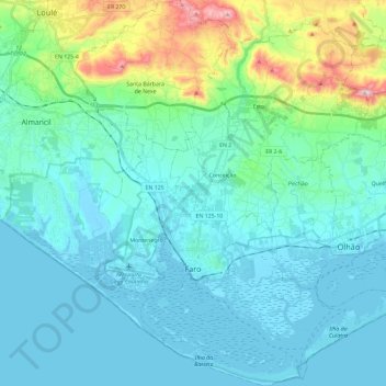
Name: Faro topographic map, elevation, terrain.
Location: Faro, Portugal (36.95997 -8.00649 37.14578 -7.80595)
Average elevation: 67 m
Minimum elevation: -4 m
Maximum elevation: 402 m
Thank you for supporting this site ❤️
Make a donation
Make a donation
Other topographic maps
Click on a map to view its topography, its elevation and its terrain.