
Thank you for supporting this site ❤️
Make a donation
Make a donation
Lublin topographic map
Click on the map to display elevation.
Thank you for supporting this site ❤️
Make a donation
Make a donation
About this map
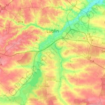
Name: Lublin topographic map, elevation, terrain.
Location: Lublin, Lublin Voivodeship, Poland (51.13981 22.45379 51.29656 22.67354)
Average elevation: 202 m
Minimum elevation: 159 m
Maximum elevation: 240 m
Thank you for supporting this site ❤️
Make a donation
Make a donation
Other topographic maps
Click on a map to view its topography, its elevation and its terrain.
Thank you for supporting this site ❤️
Make a donation
Make a donation
Dęby
Poland > Lublin Voivodeship > Tomaszów Lubelski County > Lubycza Królewska
Average elevation: 274 m
Thank you for supporting this site ❤️
Make a donation
Make a donation
Thank you for supporting this site ❤️
Make a donation
Make a donation
Kolonia Roskosz
Poland > Lublin Voivodeship > Biała Podlaska County > Roskosz
Average elevation: 148 m
Thank you for supporting this site ❤️
Make a donation
Make a donation
Zalew Nielisz
Poland > Lublin Voivodeship > Zamość County > Deszkowice Drugie
Average elevation: 202 m
Thank you for supporting this site ❤️
Make a donation
Make a donation
Kolonia Pierwsza
Poland > Lublin Voivodeship > Chełm County > Nowokajetanówka
Average elevation: 179 m
Thank you for supporting this site ❤️
Make a donation
Make a donation