
Make a donation
Sebeș topographic map
Click on the map to display elevation.
Make a donation
About this map
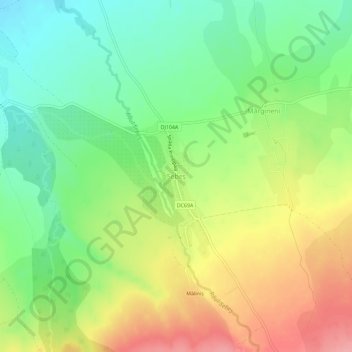
Name: Sebeș topographic map, elevation, terrain.
Location: Sebeș, Hârseni, Brașov, 507094, Romania (45.70608 25.00981 45.74608 25.04981)
Average elevation: 564 m
Minimum elevation: 520 m
Maximum elevation: 622 m
Make a donation
Other topographic maps
Click on a map to view its topography, its elevation and its terrain.
Make a donation
Make a donation
Predeal
Predeal (pronounced [preˈde̯al]; Hungarian: Predeál) is a town in Brașov County, Romania. Predeal, a mountain resort town, is the highest town in Romania. It is located in the Prahova Valley, Muntenia at an elevation of over 1,000 m (3,300 ft). The town administers three villages: Pârâul Rece, Timișu de…
Average elevation: 1,108 m
Make a donation
Make a donation
Make a donation
Make a donation
Make a donation
Make a donation
Make a donation
Make a donation
Make a donation
Ghimbav
The town is situated in the southern part of the Transylvanian Plateau, at an altitude of 559 m (1,834 ft), on the banks of the river Ghimbășel. It is located in the Burzenland ethnographic area, in the central part of Brașov County, just 8 kilometres (5 mi) west of the county seat, Brașov.
Average elevation: 544 m
Make a donation