
Cape Breton Island topographic map
Interactive map
Click on the map to display elevation.
About this map
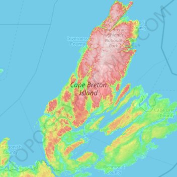
Name: Cape Breton Island topographic map, elevation, terrain.
Location: Cape Breton Island, Nova Scotia, Canada (45.54803 -61.55268 47.04205 -59.78811)
Average elevation: 66 m
Minimum elevation: -3 m
Maximum elevation: 531 m
The island is characterized by a number of elevations of ancient crystalline and metamorphic rock rising up from the south to the north, and contrasted with eroded lowlands. The bedrock of blocks that developed in different places around the globe, at different times, and then were fused together via tectonics.
Other topographic maps
Click on a map to view its topography, its elevation and its terrain.
Black Duck Run
Canada > Nova Scotia > Halifax County > East Dover
Black Duck Run, East Dover, Halifax Regional Municipality, Halifax County, Nova Scotia, Canada
Average elevation: 18 m
Mill Village
Canada > Nova Scotia > Queens County
Mill Village, Region of Queens Municipality, Queens County, Nova Scotia, B0J 2H0, Canada
Average elevation: 28 m
Charleston
Canada > Nova Scotia > Queens County
Charleston, Region of Queens Municipality, Queens County, Nova Scotia, B0J 2H0, Canada
Average elevation: 35 m
Middle Sackville
Canada > Nova Scotia > Halifax County
Middle Sackville, Halifax Regional Municipality, Halifax County, Nova Scotia, Canada
Average elevation: 103 m
Beckwith
Canada > Nova Scotia > Municipality of the County of Cumberland
Beckwith, Municipality of the County of Cumberland, Cumberland County, Nova Scotia, Canada
Average elevation: 44 m
Craigmore
Canada > Nova Scotia > Municipality of the County of Inverness
Craigmore, Municipality of the County of Inverness, Inverness County, Nova Scotia, Canada
Average elevation: 109 m
Southside Boularderie
Canada > Nova Scotia > Cape Breton Regional Municipality > Southside Boularderie
Southside Boularderie, Cape Breton Regional Municipality, Cape Breton County, Nova Scotia, Canada
Average elevation: 53 m
Hillside
Canada > Nova Scotia > Municipality of Pictou County > Hillside
Hillside, Municipality of Pictou County, Pictou County, Nova Scotia, B0K 1X0, Canada
Average elevation: 25 m
Big Beach
Canada > Nova Scotia > Cape Breton Regional Municipality > Big Beach
Big Beach, Cape Breton Regional Municipality, Cape Breton County, Nova Scotia, Canada
Average elevation: 62 m
Big Brook
Canada > Nova Scotia > Municipality of the County of Inverness > Big Brook
Big Brook, Municipality of the County of Inverness, Inverness County, Nova Scotia, Canada
Average elevation: 127 m
Bridgetown
Canada > Nova Scotia > Municipality of the County of Annapolis > Bridgetown
Bridgetown, Municipality of the County of Annapolis, Annapolis County, Nova Scotia, B0S1C0, Canada
Average elevation: 14 m
Old Holland Road
Canada > Nova Scotia > Halifax County > Fletchers Lake
Old Holland Road, Fletchers Lake, Halifax Regional Municipality, Halifax County, Nova Scotia, B2T 1A6, Canada
Average elevation: 68 m
South End
Canada > Nova Scotia > Halifax
South End, Halifax, Halifax Regional Municipality, Halifax County, Nova Scotia, Canada
Average elevation: 23 m
MacKay Brook
Canada > Nova Scotia > South Bar
MacKay Brook, South Bar, Cape Breton Regional Municipality, Cape Breton County, Nova Scotia, B1N 1M7, Canada
Average elevation: 21 m
Cape Breton County
Cape Breton Regional Municipality, Cape Breton County, Nova Scotia, Canada
Average elevation: 44 m
Clarence
Canada > Nova Scotia > Clarence
Clarence, Municipality of the County of Annapolis, Annapolis County, Nova Scotia, B0S 1M0, Canada
Average elevation: 74 m
Long Point
Canada > Nova Scotia > Long Point
Long Point, Municipality of the County of Inverness, Inverness County, Nova Scotia, Canada
Average elevation: 85 m
Economy
Canada > Nova Scotia > Economy
Economy, Municipality of Colchester, Colchester County, Nova Scotia, B0M 1J0, Canada
Average elevation: 93 m
Halifax Regional Municipality
Halifax Regional Municipality, Halifax County, Nova Scotia, Canada
Average elevation: 37 m
Bras d'Or Lake
Canada > Nova Scotia > Potlotek First Nation
Bras d'Or Lake, Chapel Island 7 Trail, Chapel Island 5, Potlotek First Nation, Richmond County, Nova Scotia, B0E 3B0, Canada
Average elevation: 0 m
Outram
Canada > Nova Scotia > Outram
Outram, Municipality of the County of Annapolis, Annapolis County, Nova Scotia, B0S 1P0, Canada
Average elevation: 109 m
LaBelle
Canada > Nova Scotia > LaBelle
LaBelle, Region of Queens Municipality, Queens County, Nova Scotia, Canada
Average elevation: 83 m
Rocky Mountain
Canada > Nova Scotia > Rocky Mountain
Rocky Mountain, Municipality of Pictou County, Pictou County, Nova Scotia, Canada
Average elevation: 150 m