
Thank you for supporting this site ❤️
Make a donation
Make a donation
Bances topographic map
Click on the map to display elevation.
Thank you for supporting this site ❤️
Make a donation
Make a donation
About this map
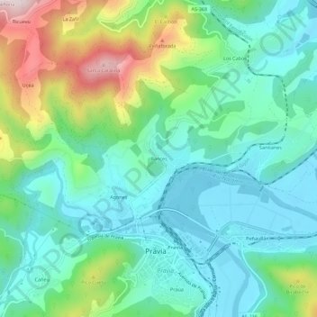
Name: Bances topographic map, elevation, terrain.
Location: Bances, Pravia, Asturias, 33120, Spain (43.48125 -6.13336 43.52125 -6.09336)
Average elevation: 128 m
Minimum elevation: 1 m
Maximum elevation: 468 m
Thank you for supporting this site ❤️
Make a donation
Make a donation
Other topographic maps
Click on a map to view its topography, its elevation and its terrain.