
Thank you for supporting this site ❤️
Make a donation
Make a donation
Anderlecht topographic map
Click on the map to display elevation.
Thank you for supporting this site ❤️
Make a donation
Make a donation
About this map
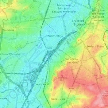
Name: Anderlecht topographic map, elevation, terrain.
Location: Anderlecht, Brussels-Capital, 1070, Belgium (50.80706 4.24377 50.85032 4.34011)
Average elevation: 51 m
Minimum elevation: 16 m
Maximum elevation: 120 m
Thank you for supporting this site ❤️
Make a donation
Make a donation
Other topographic maps
Click on a map to view its topography, its elevation and its terrain.
Thank you for supporting this site ❤️
Make a donation
Make a donation
Boitsfort - Bosvoorde
Belgium > Brussels-Capital > Watermael-Boitsfort - Watermaal-Bosvoorde
Average elevation: 96 m
Thank you for supporting this site ❤️
Make a donation
Make a donation
Parc de Laeken - Park van Laken
Belgium > Brussels-Capital > Brussels > Laeken - Laken
Average elevation: 47 m
Molenbeek-Saint-Jean - Sint-Jans-Molenbeek
Belgium > Brussels-Capital > Molenbeek-Saint-Jean - Sint-Jans-Molenbeek
Average elevation: 47 m