
Thank you for supporting this site ❤️
Make a donation
Make a donation
San Miguel de Allende topographic map
Click on the map to display elevation.
Thank you for supporting this site ❤️
Make a donation
Make a donation
About this map
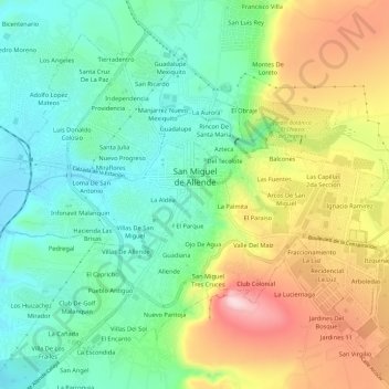
Name: San Miguel de Allende topographic map, elevation, terrain.
Location: San Miguel de Allende, Guanajuato, Mexico (20.88832 -100.77306 20.93495 -100.71385)
Average elevation: 1,964 m
Minimum elevation: 1,855 m
Maximum elevation: 2,152 m
Thank you for supporting this site ❤️
Make a donation
Make a donation
Other topographic maps
Click on a map to view its topography, its elevation and its terrain.
San Miguel de Allende
Mexico > Guanajuato > San Miguel de Allende > San Miguel de Allende
Average elevation: 2,029 m