
Make a donation
Shkozë topographic map
Click on the map to display elevation.
Make a donation
About this map
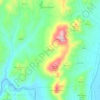
Name: Shkozë topographic map, elevation, terrain.
Average elevation: 907 m
Minimum elevation: 805 m
Maximum elevation: 1,148 m
Make a donation
Other topographic maps
Click on a map to view its topography, its elevation and its terrain.
Korçë
Albania > Southern Albania > Korçë County
As of the Köppen climate classification, Korçë falls under the periphery of the warm-summer Mediterranean climate (Csb, bordering on Dsb) zone with an average annual temperature of 10.4 °C (50.7 °F). The warmest month of Korçë is August with an average temperature of 21.3 °C (70.3 °F). By contrast,…
Average elevation: 877 m
Make a donation
Korçë
Albania > Southern Albania > Korçë County
As of the Köppen climate classification, Korçë falls under the periphery of the warm-summer Mediterranean climate (Csb, bordering on Dsb) zone with an average annual temperature of 10.4 °C (50.7 °F). The warmest month of Korçë is August with an average temperature of 21.3 °C (70.3 °F). By contrast,…
Average elevation: 877 m
Ersekë
Albania > Southern Albania > Korçë County
Ersekë (Albanian definite form: Erseka), is a town and a former municipality in southeastern Albania. At the 2015 local government reform it became a subdivision and the seat of the municipality Kolonjë. Founded in the 17th century, Erseka was the seat of the former Kolonjë District. The population at the…
Average elevation: 1,018 m