
Pulau Betong topographic map
Interactive map
Click on the map to display elevation.
About this map
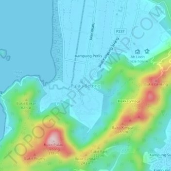
Name: Pulau Betong topographic map, elevation, terrain.
Location: Pulau Betong, Barat Daya, Penang, 11020, Malaysia (5.28712 100.18333 5.32712 100.22333)
Average elevation: 73 m
Minimum elevation: 0 m
Maximum elevation: 363 m
Other topographic maps
Click on a map to view its topography, its elevation and its terrain.
Betong Island
Malaysia > Penang > Pulau Betong
Betong Island, Pulau Betong, Southwest Penang Island District, Penang, Malaysia
Average elevation: 8 m