
Thank you for supporting this site ❤️
Make a donation
Make a donation
Pizzo Coca topographic map
Click on the map to display elevation.
Thank you for supporting this site ❤️
Make a donation
Make a donation
Pizzo Coca
The Alps are split into five climate zones, each with a different kind of environment. The climate, plant life and animal life vary on different sections or zones of the mountain such as Pizzo Coca. The initial altitude at Val Seriana, one of the recommended southern access points, is 1,100 meters and part of a valley. The valley trail rises to 1,892 meters by Rifugio Coca which is a rest stop.
Thank you for supporting this site ❤️
Make a donation
Make a donation
About this map
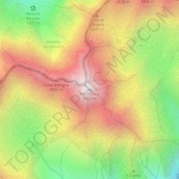
Name: Pizzo Coca topographic map, elevation, terrain.
Location: Pizzo Coca, Valbondione, Bergamo, Lombardy, Italy (46.07147 10.01149 46.07157 10.01159)
Average elevation: 2,380 m
Minimum elevation: 1,652 m
Maximum elevation: 3,042 m
Thank you for supporting this site ❤️
Make a donation
Make a donation