
Make a donation
Tehran topographic map
Click on the map to display elevation.
Make a donation
Tehran
Northern Tehran is at the foot of Alborz, starting at an elevation of 1,800 meters (5,900 ft), with many houses and streets on steep slopes and hills. There is a stretch of hills in the middle of the city (which historically divided Tehran and Shemiran) with its highest point at 1,500 metres (4,900 ft). Southwards and westwards of those hills, Tehran is less steep. On the east, there are numerous hills, with the highest point at 1,950 metres (6,400 ft). The southern end of Tehran (Rey) is at 1,100 metres (3,600 ft), next to a single mountain (Raga) at 1,500 metres (4,900 ft).
Make a donation
About this map
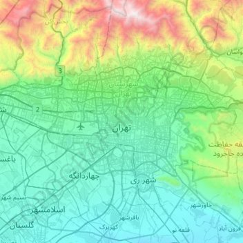
Name: Tehran topographic map, elevation, terrain.
Average elevation: 1,539 m
Minimum elevation: 976 m
Maximum elevation: 3,943 m
Make a donation
Other topographic maps
Click on a map to view its topography, its elevation and its terrain.
Make a donation
Make a donation