
Make a donation
Canillas de Aceituno topographic map
Click on the map to display elevation.
Make a donation
Canillas de Aceituno
Canillas de Aceituno has an altitude of around 524 meters at the foot of the Sierra de Tejeda and is crowned by the peak of La Maroma at 2,068 meters, the highest in the province. It is a town of narrow streets that are immaculately whitewashed, Moorish arches and corners of flowers.
Make a donation
About this map
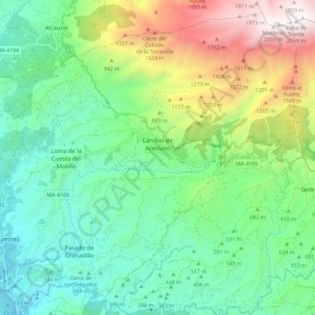
Name: Canillas de Aceituno topographic map, elevation, terrain.
Location: Canillas de Aceituno, La Axarquía, Malaga, Andalusia, Spain (36.83309 -4.13762 36.90618 -4.03815)
Average elevation: 677 m
Minimum elevation: 63 m
Maximum elevation: 2,068 m
Make a donation
Other topographic maps
Click on a map to view its topography, its elevation and its terrain.
Make a donation
Maroma
Spain > Andalusia > La Axarquía > Canillas de Aceituno
La Maroma, also known as Tejeda, at an altitude of 2069 m, is the highest peak of the Sierra de Tejeda, Penibaetic System, Spain. The summit is located in the region of Axarquía on the border between the provinces of Granada and Málaga.
Average elevation: 1,706 m
Make a donation
Make a donation