
Make a donation
Travanca de Lagos topographic map
Click on the map to display elevation.
Make a donation
About this map
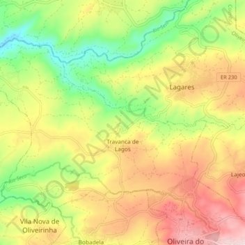
Name: Travanca de Lagos topographic map, elevation, terrain.
Location: Travanca de Lagos, Oliveira do Hospital, Coimbra, Portugal (40.36912 -7.93551 40.41166 -7.85484)
Average elevation: 362 m
Minimum elevation: 192 m
Maximum elevation: 544 m
Make a donation
Other topographic maps
Click on a map to view its topography, its elevation and its terrain.
Make a donation
Make a donation
Make a donation
Make a donation
Make a donation
Make a donation
Make a donation
Lousã
Portugal > Coimbra > Lousã e Vilarinho
Lousã sits at around 200 m (660 ft) high, and it currently has an active station at its aerodrome, but because this station is relatively new, data from the older, now inactive station in the mountains nearby, at a higher altitude, is also represented in the climate chart below.
Average elevation: 335 m
Make a donation
Make a donation
Ninho do Grou
Portugal > Coimbra > Seixo de Gatões > Seixo de Gatões > Ninho do Grou
Average elevation: 60 m
Make a donation