
Thank you for supporting this site ❤️
Make a donation
Make a donation
Les Écarts topographic map
Click on the map to display elevation.
Thank you for supporting this site ❤️
Make a donation
Make a donation
About this map
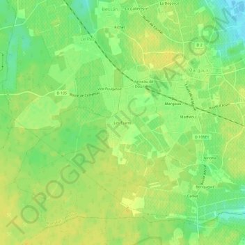
Name: Les Écarts topographic map, elevation, terrain.
Average elevation: 16 m
Minimum elevation: 2 m
Maximum elevation: 23 m
Thank you for supporting this site ❤️
Make a donation
Make a donation
Other topographic maps
Click on a map to view its topography, its elevation and its terrain.
Thank you for supporting this site ❤️
Make a donation
Make a donation
Château Brane-Cantenac
France > Nouvelle-Aquitaine > Gironde > Margaux-Cantenac > Ninotte
Average elevation: 14 m