
Thank you for supporting this site ❤️
Make a donation
Make a donation
Reichenbach im Vogtland topographic map
Click on the map to display elevation.
Thank you for supporting this site ❤️
Make a donation
Make a donation
About this map
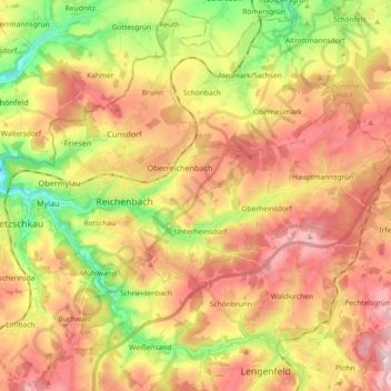
Name: Reichenbach im Vogtland topographic map, elevation, terrain.
Location: Reichenbach im Vogtland, Vogtlandkreis, Saxony, Germany (50.58072 12.23997 50.66328 12.42355)
Average elevation: 408 m
Minimum elevation: 288 m
Maximum elevation: 514 m
Thank you for supporting this site ❤️
Make a donation
Make a donation