
Make a donation
Catamarca topographic map
Click on the map to display elevation.
Make a donation
Catamarca
The province is located in the semi–arid region of Argentina. Mean annual precipitation of the province is around 400 to 500 mm (16 to 20 in) which decreases significantly to the west. The province is characterized by the presence of different microclimates based on variations in altitude. In general, there are three different climatic zones found within the province.
Make a donation
About this map
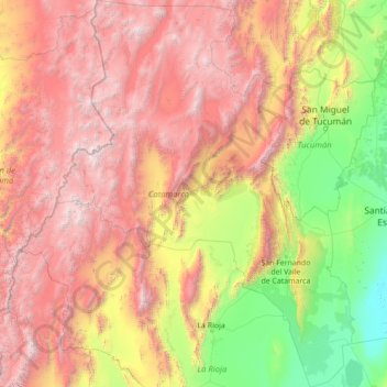
Name: Catamarca topographic map, elevation, terrain.
Location: Catamarca, Argentina (-30.11956 -69.09521 -25.16857 -64.78072)
Average elevation: 2,292 m
Minimum elevation: 113 m
Maximum elevation: 6,688 m
Make a donation
Other topographic maps
Click on a map to view its topography, its elevation and its terrain.
San Juan
San Juan is ranked second among the wine-producing provinces of Argentina. It has a cultivated area of 116,700 acres at altitudes of between 1,970 (601m) and 4,590 feet (1399m) above sea level. This region specializes in Syrah, Malbec, Cabernet Sauvignon, Bonarda, Chardonnay and Torrontés. Because of this…
Average elevation: 694 m
ASENTAMIENTO PUENTE OTERO
Argentina > Jujuy > Municipio de San Salvador de Jujuy
Average elevation: 1,287 m
Make a donation
Make a donation
Maipo
Argentina > Mendoza > Distrito Pareditas
The region's climate is transitional between the drier Mediterranean climate of the peaks to the north and the cold, moist climate of Chilean Patagonia. Hence, while less glaciated than Patagonia, it has more permanent snow on the wet, Chilean side than peaks of similar elevation to the north.
Average elevation: 4,747 m
Make a donation