
Thank you for supporting this site ❤️
Make a donation
Make a donation
San José topographic map
Click on the map to display elevation.
Thank you for supporting this site ❤️
Make a donation
Make a donation
About this map
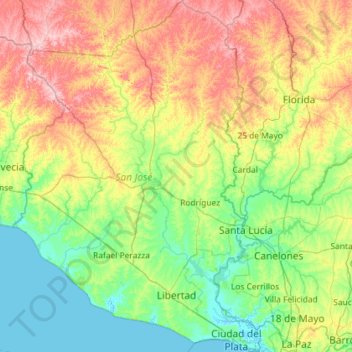
Name: San José topographic map, elevation, terrain.
Location: San José, Uruguay (-34.78408 -57.15261 -33.83215 -56.34155)
Average elevation: 60 m
Minimum elevation: -3 m
Maximum elevation: 206 m
Thank you for supporting this site ❤️
Make a donation
Make a donation
Other topographic maps
Click on a map to view its topography, its elevation and its terrain.
Manzana 9190
Uruguay > Canelones > Municipio de Ciudad de la Costa > Ciudad de la Costa
Average elevation: 10 m
Thank you for supporting this site ❤️
Make a donation
Make a donation
Cerro Catedral
Cerro Catedral ("Cathedral Hill"), also known as Cerro Cordillera, is a peak and the highest point of Uruguay, with an altitude of 513.66 m (1,685.2 ft). It is located north of Maldonado Department, in the municipality of Aiguá, in a hill range named Sierra Carapé, which constitutes part of a larger range…
Average elevation: 415 m
Thank you for supporting this site ❤️
Make a donation
Make a donation